
Following a Mesquite Street by Address
A street-by-street search can identify public parcel and document history, but it cannot certify every person at a location. Begin with the address in the county property system. The resulting APN, or assessor parcel number, is the dependable bridge to the Recorder’s instrument index and map context. A street name alone is less precise because it can have direction, type, boundary, or historical-label variations. Keep every source’s date and do not turn an owner field into an occupancy claim.
- Enter the address in the Clark County Assessor search and preserve all plausible parcel candidates.
- Record the APN, legal description, situs label, and legal City/Town value from the parcel result.
- Open the same area in county GIS, then click nearby parcels for their APNs and legal descriptions.
- Run each APN through the Recorder parcel index to identify dated instruments and party roles.
- Use voter products only within their statutory limits, and use library directory sources when the question concerns an earlier address era.
That flow moves from a physical address to the record systems that describe it. It also makes a clear distinction between a parcel, an institution’s named party, and a person’s actual current location.
Mesquite Street Directory Assessor Controls
The Clark County Assessor provides the local street-directory starting point through parcel number, owner name, address, subdivision name, subdivision owners, book and page, parcel tree, and parcel-map routes. Its address form uses a required street name with optional street number, direction, and street type. A phonetic-match checkbox is useful for a name search, while the record-preference choice can expose current data or present and prior-owner context.
| Address field | How to use it for a Mesquite street search |
|---|---|
| Street Number | Optional; results can include locations within three blocks, so inspect the candidate list. |
| Street Direction | Select or test the direction rather than assuming it from a historic address. |
| Street Name and Type | Use the required name, then compare Road, Drive, Boulevard, and abbreviation variants. |
| City/Town | A legal-boundary control, not a postal mailing-city confirmation. |
| Current or present/prior | Choose the view that best matches the date being investigated. |
The Assessor address-search page displays these controls for Mesquite and other Clark County locations. Its three-block result behavior is an important local quirk. Use it as a discovery feature, then narrow with APN, street type, subdivision, and the Recorder’s legal description instead of choosing the first return.
Mesquite Street Directory Map Context
Clark County GIS Open Web, GISMO, and Recorder GIS InfoMapper supply parcel boundaries and map context for a street segment. The captured research supports map browsing and parcel interaction, but it did not expose a confirmed list of live layers, buffer controls, or output fields. Use the documented map-browse and parcel-click method rather than assuming an unverified radius or adjacency tool exists.
Locate the APN or street, zoom to the segment, click neighboring parcel polygons, and record each APN and legal description. Then return to the Assessor and Recorder for the underlying parcel and instrument data. Assessment maps are orientation tools compiled for assessment purposes. They are not a survey or a legal boundary determination, and recorded instruments carry more detail when the exact line matters.
- Parcel
- A defined tract identified by an APN in the county assessment system.
- Situs address
- The location label associated with a parcel, distinct from the mailing field.
- Plat
- A recorded subdivision map that can connect lots and blocks to a legal description.
- Criss-cross directory
- A historical directory arranged by address so a past occupant can be checked against the alphabetical listing.
Mesquite Street Directory Deed Trail
The Recorder’s Acclaim search is the formal document layer for a Mesquite street directory. Its name screen accepts last name, first name, company name, Starts With, Contains, or Exact matching, book type, date range, show-name choice, and document type. The parcel route accepts an APN plus match mode, dates, and document type. An APN is usually a firmer bridge from a current parcel to an earlier instrument than the street address by itself.
The Recorder name-search form shows the grantor-grantee style controls used when a parcel trail points to a named party.
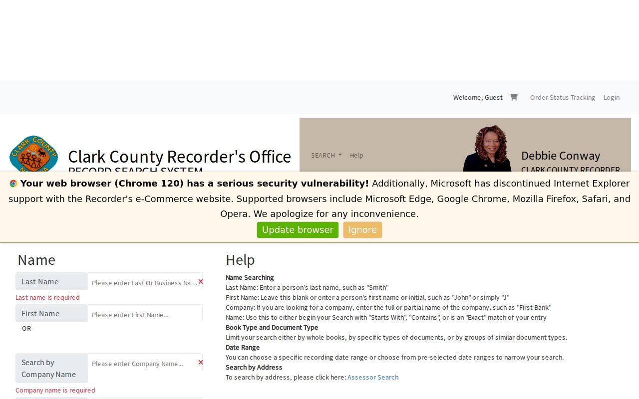
Read the party role and document type. A grantor transfers an interest, while a grantee receives one. Neither label alone says who is at the address now.
The Recorder parcel-search form provides the complementary APN route.
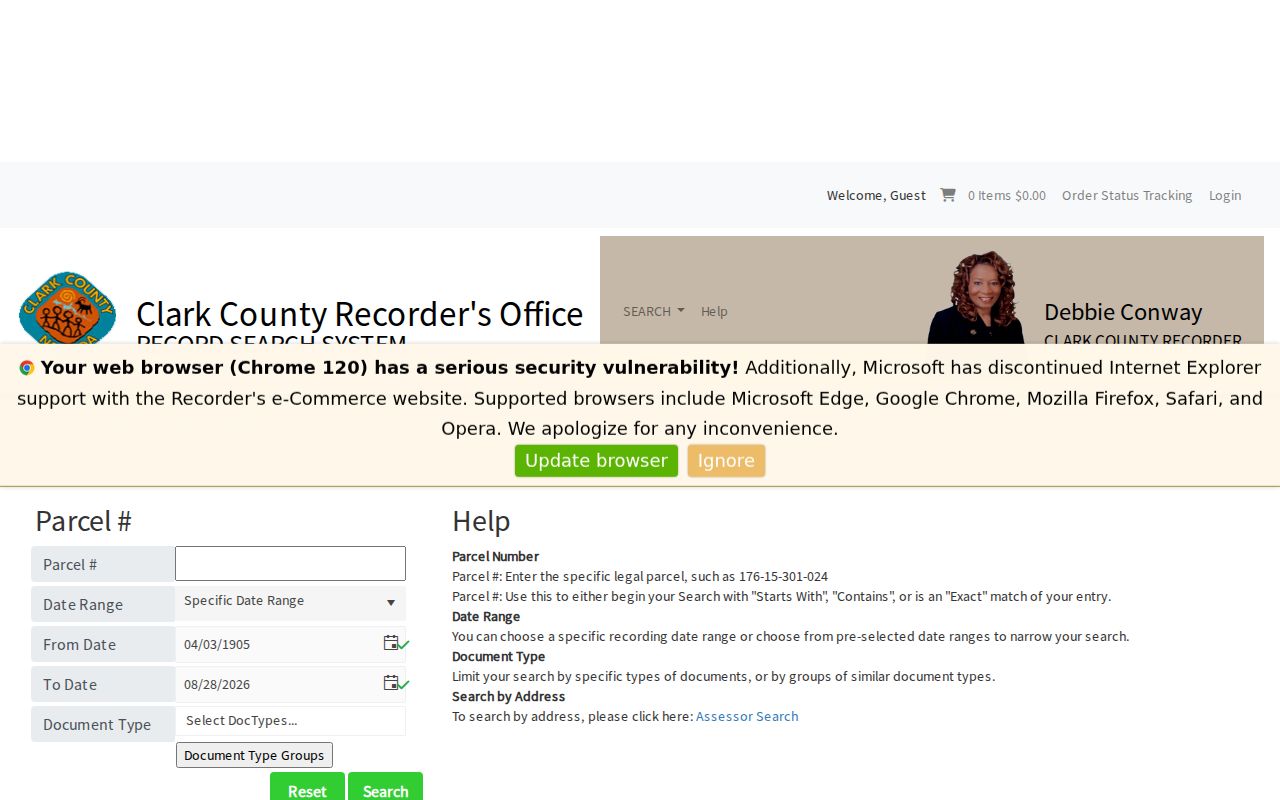
Acclaim makes brief index information available without charge, but original images are not freely displayed online. Inspect them at the Recorder public viewing area or order a copy when the legal description, signature, redaction, or exact document language is necessary.
Mesquite Street Addresses Need Four Labels
A Mesquite street directory can be wrong if it treats a mailing label as the whole location. The research supports keeping four values apart: the historical address wording, USPS delivery geography, legal City/Town, and parcel or APN. The Assessor’s City/Town choice follows legal boundary rather than mailing city, and nearby Bunkerville or rural Virgin Valley records can share a Mesquite mailing context.
Preserve original spellings such as First North versus 1st North, direction abbreviations, unit or lot labels, rural-route wording, and Mesquite Boulevard variants. If the legal jurisdiction is unclear, search the street name without prematurely setting City/Town, compare parcel and subdivision information, then check the Recorder by APN and year. A current street list proves only current street existence; it cannot settle an earlier municipal boundary.
Note: No official full Mesquite street-renumbering, renamed-street, annexation, or historical ZIP crosswalk was located in the research, so unresolved variants should remain documented rather than guessed.
Mesquite Street Directory Record Layers
Address-keyed record systems reveal different things along a Mesquite street. The right order links a parcel to its formal document history, then adds city or election information only for the limited purpose each source supports. A street name ties sources together, but the APN and legal description are the stronger identifiers when multiple candidates share a similar address.
| Address record | Mesquite keeper | Street-level value | Access channel |
|---|---|---|---|
| Assessor parcel card | Clark County Assessor | APN, owner clue, situs and assessment context | Online owner, address, parcel, or subdivision routes |
| Parcel map | County GIS / Assessor | Street segment, boundaries, adjacent parcel context | Map browse and parcel interaction |
| Recorded instruments | Clark County Recorder | Party roles, dates, legal descriptions, maps, liens | Free brief index; office viewing or ordered copy |
| Election products | Clark County Election Department | Regulated precinct and voter-list context | Weekly files, request products, or walking lists |
| Permit and code file | Mesquite Building / Code Enforcement | Work, inspection, application, or closure chronology | Portal or narrow address/APN request |
Parcel data can connect the assessment roll to deeds and permits. A street name can locate nearby parcels, but it should not override an APN when a record’s address format changes. For historical directory collections rather than current parcel work, use the Mesquite city directories route.
Mesquite Street Permit and Code Files
Mesquite Building Division maintains building records and handles permits, inspections, plan checks, occupancy records, and information requests. An effective address request names the street address or APN, permit number if known, work type, issue or final date, inspection status, certificate of occupancy, and applicant or contractor. The public portal is linked at mesquite.onlinegovt.com, but its complete public result fields were not exposed in the research.
Code Enforcement has no located public case lookup. A request should state the address or APN, date range, case or violation type, inspection, notice, closure, final disposition, and appeal if applicable. If a parcel lies outside city jurisdiction, Clark County Code Enforcement and the Public Response Office may be the proper route. Permit and code information can explain a property timeline; it does not identify every person connected to the address.
Mesquite Street Voter Products
Clark County publishes weekly active and all voter-data files, custom county or district products, and precinct walking lists. The walking-list interface uses a precinct selection and requires popups; confidential voters are excluded. That can provide a date-specific election record for a street area, but it is not a complete block roster. The county’s Voter Services login is a personal service flow, and its live fields were not captured in this research.
NRS 293.440 describes voter-list access, while NRS 293.558 allows address and phone withholding. File status has its own administrative meaning: active means election mail has not been returned, while inactive means the address is not current in the election file but eligibility may continue. Use a source date, respect file terms, and never infer that an omitted person is absent from a neighborhood.
Mesquite Street Directory History Clues
Historic street research often needs an address-to-name source after the parcel trail is established. Mesquite Library research resources include HeritageQuest, Gale Directory Library, and Chronicling America, while UNLV and the Nevada Historical Society offer newspaper, microfilm, and archive paths. The exact Mesquite and Virgin Valley printed directory runs, reverse files, and yearbook holdings were not published in the research. Ask a librarian or repository staff member for the catalog record rather than inserting a presumed year range.
When a historical address is ambiguous, preserve the original label and compare it with a released federal census year, newspaper date, deed sequence, permit, cemetery record, or museum catalog clue. The parcel’s legal description and an instrument number often resolve a doubtful street label better than a broad name search. The past residents page focuses on that backward address trail.
Mesquite Street Directory Privacy Limits
Street and address research has firm boundaries. There is no public DMV address lookup in the research, and federal DPPA rules restrict motor-vehicle personal information. Utility customer records are private. Confidential voters, Nevada Confidential Address Program participants, juvenile files, sealed matters, and protected identifiers must not be reconstructed from a patchwork of sources. A parcel owner, mailing field, and named document party are separate facts.
NRS Chapter 239 allows a request to the actual custodian, subject to confidentiality law. Narrow the request by department, address or APN, date range, and record type. Ask for separable nonconfidential material when necessary, and retain the agency’s stated reason if access is denied or delayed.